
Raleigh ZIP Code Directory Coverage
Wake GIS identifies fifteen mapped Raleigh street-delivery ZIP areas for orientation. The list is useful for grouping a search, but each area is only an approximate local frame. The official research does not identify post-office station names for these rows, so the Post Office column intentionally directs each address back to USPS instead of assigning a name that has not been documented. Check the current address result and the Wake polygon before using any label in a record note.
| ZIP | Areas Covered | Post Office | Notes |
|---|---|---|---|
| 27601 | Downtown/core orientation | Validate with USPS address result | Mapped street-delivery area; orientation only |
| 27603 | South/southeast orientation | Validate with USPS address result | Mapped street-delivery area; orientation only |
| 27604 | East/northeast orientation | Validate with USPS address result | Mapped street-delivery area; orientation only |
| 27605 | West/northwest orientation | Validate with USPS address result | Mapped street-delivery area; orientation only |
| 27606 | Raleigh street-delivery area | Validate with USPS address result | Check current polygon for local coverage |
| 27607 | West/northwest orientation | Validate with USPS address result | Mapped street-delivery area; orientation only |
| 27608 | Raleigh street-delivery area | Validate with USPS address result | Check current polygon for local coverage |
| 27609 | East/northeast orientation | Validate with USPS address result | Mapped street-delivery area; orientation only |
| 27610 | South/southeast orientation | Validate with USPS address result | Mapped street-delivery area; orientation only |
| 27612 | West/northwest orientation | Validate with USPS address result | Mapped street-delivery area; orientation only |
| 27613 | West/northwest orientation | Validate with USPS address result | Check county because Raleigh/Durham contexts occur |
| 27614 | West/northwest orientation | Validate with USPS address result | Mapped street-delivery area; orientation only |
| 27615 | West/northwest orientation | Validate with USPS address result | Mapped street-delivery area; orientation only |
| 27616 | East/northeast orientation | Validate with USPS address result | Mapped street-delivery area; orientation only |
| 27617 | West/northwest orientation | Validate with USPS address result | Mapped street-delivery area; orientation only |
These postal-area rows do not name neighborhoods or declare city limits. Wake's official reference map and dataset support the mapped street-delivery set, while a single address still needs USPS and parcel-level checking.
Raleigh Postal Orientation Only
For a quick Raleigh orientation, 27601 is the downtown/core label. The research places 27603 and 27610 broadly to the south or southeast; 27604, 27609, and 27616 to the east or northeast; and 27605, 27607, 27612, 27613, 27614, 27615, and 27617 to the west or northwest. That is a map-reading aid, not a list of neighborhood boundaries. The remaining mapped street-delivery codes should likewise be resolved through the current polygon or a specific address.
A Raleigh address may sit near a city line, an ETJ, a county edge, or a postal-city label that does not match the municipal label used in a court, tax, or city system. Old records can add another layer by using the nearest post office or a township. Preserve the source date, rather than forcing past and present labels to agree.
Raleigh Postal Boundaries in Wake GIS
The Wake ZIP Codes dataset is the strongest geographic source for Raleigh ZIP boundaries in the research. It identifies the Wake GIS Addressing Team as steward, notes that boundaries can change with property-line and USPS data changes, and reports an update on March 17, 2026. Its REST layer is available from Wake GIS. The current polygon is more useful for spatial context than an older reference PDF, but it is still not proof of mailing delivery or occupancy.
The published Wake ZIP dataset metadata is shown below with the data steward and update context.
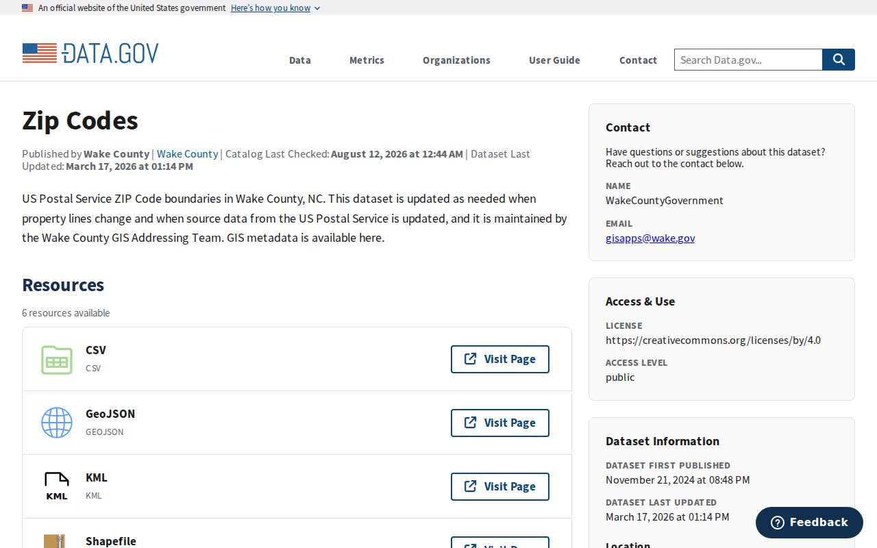
Use the data date beside a Raleigh map result. A future boundary change should not make an earlier ZIP note look like a claim about the current map.
Find Raleigh Residents by ZIP
A ZIP is a narrowing device, not a resident list. Start with a specific mailing address, establish its current ZIP, then use the polygon and parcel tools to learn which city, county, and other jurisdictional layers apply. If the question becomes street-specific, the Raleigh street directory has the address-keyed workflow. Keep an address, a parcel owner, a voter record, and a directory listing as separate roles.
- Run the street address through USPS ZIP Code Lookup and save the returned city and ZIP line.
- Locate the address in the Wake ZIP polygon and Raleigh/Wake iMAPS; record county, city or ETJ, and civic layers separately.
- Use Wake real-estate search for the address or parcel relationship. The documented field reference does not establish a ZIP-only resident search.
- When a ZIP crosses a county boundary or a tax jurisdiction matters, check the NCDOR table or county GIS and preserve conflicting labels.
USPS confirms postal addressing only. Its own warning says a result does not confirm a person or company at an address, so a Raleigh ZIP result should never be treated as a roster of residents.
Raleigh ZIP Lookup Search Fields
The documented USPS lookup offers three useful routes: By Address, By City and State, and Cities by ZIP. It is the address-validation step in a Raleigh postal workflow. Wake real-estate and iMAPS searches then add parcel or map context. Do not claim a portal has a ZIP filter unless the official source captures one. The research did not capture a direct ZIP-only filter for Wake parcel records.
| System | Field or mode | Use and limit |
|---|---|---|
| USPS | Street Address, City, State | Validates a mailing ZIP; not a person match |
| USPS | Company, optional | Optional mailing field; does not prove an entity is present |
| USPS | By City and State / Cities by ZIP | Lists postal results for a place or ZIP |
| Wake real-estate | Address, owner, REID, PIN, street | Parcel context after the ZIP is checked |
| iMAPS | Address, owner, place, intersection | Map and jurisdiction context, not a survey |
Raleigh Voter Records by ZIP
North Carolina voter data can be useful only as a dated registration source. The State Board voter-data page provides current county and statewide files plus historical snapshots, and Wake data is available through the listed official download routes. The captured law allows lists by fields such as party, gender, race, age, registration date, precinct, districts, and voter history. It does not turn a ZIP boundary into proof of current residence or a complete directory of people in that postal area.
Residential and mailing address fields are subject to protected-address rules. Date of birth, Social Security number, driver-license number, email, photo-ID material, and registration-agency identity are confidential. A voter signature can be viewed but not copied or traced. The research did not capture an official Wake ZIP filter or a current custom-file request form, delivery format, fee, or direct Wake FTP link. Use the State Board data page and G.S. 163-82.10/.13 as the starting point rather than filling those gaps with assumptions.
Raleigh Postal Directory Terms
Postal terms can look alike while serving different functions. The distinction matters when a Raleigh address is compared with a tax record, a voter record, a court location, or a historical directory. A carrier route and a ZIP+4 refine delivery handling, but neither replaces a parcel boundary or city-limit check. Special ZIP labels also need stronger validation before they are associated with a place.
- ZIP and ZIP+4
- A five-digit postal delivery area and its more specific four-digit extension. Neither is a municipal boundary.
- PO-box ZIP
- A postal code used for post-office boxes. It should not be called an ordinary Raleigh street-delivery area without USPS validation.
- Unique ZIP
- A code associated with a single organization or special postal use. Confirm its current service through USPS before describing it.
- Carrier route
- A delivery sequence used by USPS. It can help route mail but does not establish a neighborhood or person relationship.
Note: A postal directory organizes ZIP geography, while county, city, precinct, and parcel data answer different Raleigh jurisdiction questions.
Raleigh ZIPs and City Limits
ZIP boundaries and Raleigh city limits are different systems. The NCDOR ZIP/county table demonstrates the problem locally: 27613 appears with Raleigh and Durham County in the tax table. A postal Raleigh label therefore cannot establish Wake County jurisdiction. Check the address in USPS, the Wake polygon, iMAPS county and municipal layers, and the NCDOR table when a tax or legal boundary matters.
Raleigh's Neighborhood Registry uses current civic group boundaries, not ZIP boundaries. A group label can add local context, but it cannot identify every person at an address or replace a postal, parcel, or city-limit check.
Raleigh municipal geography also changes over time through annexation and city-limit changes. A historic document may use a postal city or township that differs from a current iMAPS label. That discrepancy can explain a search failure without showing that the address or the person record is wrong.
Raleigh Special Postal Codes
Raleigh appears in state and tax lists with PO-box, institutional, unique, and other special-use codes beyond the fifteen mapped street-delivery ZIPs. The research lists examples such as 27602, 27611, 27619 through 27629, 27634 through 27636, 27650, 27656, 27658, 27661, 27668, 27675 through 27676, 27690, 27695, and 27697 through 27699. Those numbers should not be turned into residential-area descriptions without a USPS city/state result and a current feature or label.
The research did not capture a complete current USPS export that separates every street, PO-box, unique, and institutional Raleigh ZIP. This is a real limit, not a reason to assume that a special code covers homes or a particular neighborhood. Check each use case through the current postal lookup.
Raleigh ZIP Mismatch Check
When a Raleigh ZIP search returns conflicting geography, follow the four-source check: USPS for the mailing line, Wake GIS for the ZIP polygon, iMAPS for county and municipal layers, and NCDOR for county or tax context. Save the date, address format, returned label, and source role. This approach is especially important near Wake, Durham, Johnston, or Franklin county edges, where a postal label may not match the jurisdiction that keeps a record.
Wake's dataset update on March 17, 2026 is a useful date anchor for map-based research. A ZIP can narrow an old directory or parcel search, but it should not create assumptions about neighbors, ownership, city limits, or current presence. Those questions require their own official record and a separate verification step.